
Business Details
50+ Years
experience
Civil Engineering & Land Surveying Experts Since 1971
Ogden Engineering has been delivering comprehensive civil engineering and land surveying solutions since 1971. Our in-house expertise eliminates the need for subcontracting, ensuring seamless project execution from initial survey to final engineering implementation. With over five decades of experience in Western Wisconsin, we specialize in commercial and residential site planning, subdivision design, and precise land surveying services. Our team's deep understanding of local regulations and environmental requirements enables efficient permitting and compliance for every project. By maintaining direct communication between surveyors and engineers, we reduce delays and enhance accuracy across all phases of development.From topographic surveys to stormwater management systems, our professionals apply advanced technology like GPS and robotic total stations to deliver reliable results. Clients benefit from our proven track record in designing award-winning subdivisions such as Troy Burne and Trumpeter Valley while maintaining a commitment to personalized service. Our integrated approach streamlines complex projects involving sanitary sewer systems, road infrastructure, and erosion control measures. This holistic methodology ensures cost-effective solutions tailored to each client's unique needs while upholding our founding principles of honesty and dedicated service established in 1971.


Services
Land Surveying
Civil Engineering
Property Surveys
Subdivision Plats
Topographic Surveys
Construction Staking
ALTA/ACSM Surveys
Commercial Site Plans
Erosion Control Plans
Storm Water Design
Details
- Year established: 1971
Highlights and features
- We offer complete in-house engineering and surveying services
- Our team has over 50 years of local Wisconsin project experience
- We utilize advanced GPS and robotic surveying technology
- Direct engineer-surveyor collaboration streamlines project timelines
- Proven track record with complex subdivision developments
Services
Land Surveying
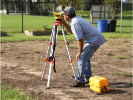
Our comprehensive land surveying services include boundary determination, topographic mapping, and construction layout. We provide ALTA/ACSM standards surveys, elevation certificates, and subdivision plats for residential and commercial properties. Utilizing GPS and robotic total station technology ensures precise measurements for all project types.
Civil Engineering
We offer complete civil engineering solutions for site development projects. Our services include preparing erosion control plans, designing stormwater management systems, and creating sanitary sewer and watermain infrastructure. Our engineers develop site plans that meet DNR and county permitting requirements for both commercial and residential developments.
Subdivision Design
Our subdivision design services encompass creating detailed plat maps, grading plans, and road/driveway layouts. We handle all necessary permitting documentation and coordinate with local authorities to ensure compliance with current development standards and environmental regulations.
Construction Staking
We provide accurate construction staking services using advanced surveying equipment. Our team establishes precise reference points for building foundations, utilities, and infrastructure improvements to guide construction activities according to approved plans.
Erosion Control
Our erosion control planning services include developing comprehensive stormwater management strategies. We design systems that prevent soil erosion, manage runoff, and protect water quality while meeting all regulatory requirements for land development projects.
People
James Filkins
Civil Engineering Project Lead
With extensive experience in civil engineering design, James Filkins specializes in site development and infrastructure planning. He manages all engineering aspects of projects from initial concept through final implementation.
Dan Kugel
Land Surveying Project Lead
Dan Kugel brings decades of surveying expertise to Ogden Engineering. He oversees all land surveying operations, ensuring precise measurements and accurate boundary determinations for residential and commercial properties.
Questions
What areas do you serve?
We primarily serve Western Wisconsin, providing engineering and surveying services to residential, commercial, and municipal clients throughout the region.
What surveying technology do you use?
Our team utilizes GPS equipment, robotic total stations, and CAD drafting software to ensure precise measurements and accurate project documentation.
Can you handle both surveying and engineering needs?
Yes, we provide complete in-house services for both land surveying and civil engineering projects, eliminating the need for multiple contractors.
How do you handle project permitting?
We prepare all necessary documentation for DNR and county permits, ensuring your project meets regulatory requirements throughout the development process.
What experience do you have with subdivisions?
Since 1971, we've designed numerous subdivisions including award-winning developments like Troy Burne and Trumpeter Valley with comprehensive site and infrastructure planning.
What are your office hours?
Our office is open Monday-Thursday 8:00 AM - 4:30 PM, Friday 8:00 AM - 12:00 PM, and closed weekends for client consultations and project coordination.