 I provide drone services to the engineering and construction industry, focusing on project progress monitoring, mapping, photogrammetry, and inspections of buildings and assets. This is achieved through the use of 3D modeling and LIDAR & IR Thermal Imaging technologies. These services are designed to support structural building envelope engineers and contractors, as well as insurance companies conducting asset inspections as required by Florida Statutes Sec. 553.899 and 718.112.
Our drone services play a crucial role in the initial visual examination, offering a valuable resource. By utilizing our services, your team can receive a comprehensive and actionable dataset, ultimately saving time, money, and reducing safety issues.
Served areas
- Florida
Business details
- Licensed
Highlights and features
- Precision aerial mapping for construction and land development projects
- High-quality 3D modeling and orthomosaic mapping solutions
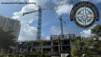
- Comprehensive construction progress monitoring and reporting
- Cinematic 4K aerial videography for marketing and documentation
- Augmented reality integration for underground utility visualization
- Licensed and insured FAA Part 107 drone operations
Payment methods
- Cash
- Debit cards
- Credit cards
Services
 Technology Surveys & Inspections delivers innovative drone-based surveying and 3D modeling solutions that enhance project accuracy and efficiency. Our expertise in aerial and terrestrial imaging supports construction progress tracking, mapping, and inspections for architects, engineers, and builders. Utilizing LiDAR, advanced sensors, and AI-powered analysis, we ensure clients receive precise, professional deliverables that drive superior project outcomes.
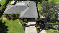
With our 3D Models service, we integrate drone-based imaging technology to create precise, data-rich models for structural evaluations. Our comprehensive datasetsfeaturing orthomosaic imagery, thermal mapping, and 3D reconstructionempower engineers to perform faster and safer inspections. Designed to align with Floridas milestone inspection requirements, our approach improves efficiency while maintaining exceptional accuracy and compliance standards.
 Our drone imaging services deliver high-quality maps, models, and data designed for general informational use. While we take care to ensure accuracy, our outputs are not professional land surveys and should not be used to determine legal boundaries or property lines. For certified survey work or legal purposes, please consult a licensed surveyor. Use of our materials constitutes acceptance of these conditions.
Reviews

Be the first to review Technology Surveys & Inspections Drone Services.
Write a Review