Business Details
23 Years
experience
Emergency
services
Civil Engineering & Land Surveying Experts in MA
Bracken Engineering is a leading civil engineering and land surveying firm dedicated to delivering comprehensive site development solutions across Southeastern Massachusetts, Cape Cod, and the Islands. With over two decades of experience, our team combines technical expertise with a client-centric approach to navigate complex projects from inception to completion. Our services span surveying, engineering design, drone photogrammetry, and environmental permitting, serving diverse sectors including commercial, residential, and industrial developments. We prioritize effective communication, community engagement, and environmentally conscious practices to ensure sustainable outcomes. Our team of licensed professionals brings decades of combined experience, offering tailored solutions for architects, developers, real estate agents, attorneys, and homeowners.By integrating advanced technology with traditional methodologies, we provide precise data and innovative designs that meet regulatory requirements while protecting natural resources. Our commitment to excellence is demonstrated through projects like the Manomet Bluff stabilization, where we addressed critical erosion challenges. We maintain active involvement in local communities and professional organizations, reinforcing our reputation as trusted advisors in civil engineering and land surveying. Our corporate mantra of C.A.R.E. (Communication, Awareness, Reason, Empathy) guides every decision, ensuring we balance client needs with environmental stewardship. With offices in Bourne, Nantucket, and Mansfield, we offer localized expertise backed by industry-leading certifications and technical capabilities.
Services
Land Surveying
Civil Engineering
Environmental Permitting
Drone Photogrammetry
Site Development
Floodplain Management
Septic System Design
Coastal Stabilization
Construction Monitoring
Utility Mapping
Details
- Year established: 2003
Highlights and features
- We combine 30+ years of field and office experience with licensed professionals.
- Our team holds certifications in floodplain management, soil evaluation, and drone operations.
- We maintain active involvement in Massachusetts Association of Land Surveyors and Civil Engineers.
- Our drone photogrammetry services enhance survey accuracy and project efficiency.
- We specialize in navigating complex environmental permitting requirements.
Services
Land Surveying
Our land surveying services provide precise property measurements and boundary determinations using advanced technology. Our licensed surveyors conduct title research, property line surveys, and construction layout for residential, commercial, and industrial clients. We deliver accurate data for real estate transactions, site development, and legal documentation.
Civil Engineering
We offer comprehensive civil engineering solutions from concept to completion, including site planning, drainage systems, and infrastructure design. Our team handles projects ranging from residential septic systems to large commercial developments, ensuring compliance with local regulations and environmental standards.
Environmental Permitting
Our environmental permitting specialists navigate complex regulatory requirements for coastal and wetland projects. We prepare documentation for Chapter 91 licenses, floodplain permits, and resource area protections while balancing development needs with ecological conservation.
Drone Photogrammetry
We utilize FAA-certified drone pilots and photogrammetry technology to create detailed topographic maps and 3D models. This technology enhances survey accuracy, reduces field time, and provides comprehensive data for construction monitoring and site analysis.
Coastal Stabilization
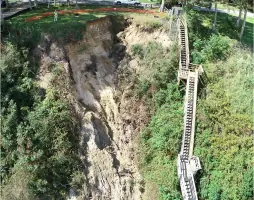
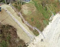
Our coastal stabilization services address erosion challenges through engineered solutions like the Manomet Bluff restoration. We combine structural reinforcements with natural vegetation to protect infrastructure while maintaining ecological integrity along coastal areas and waterways.
People
Don Bracken, Jr.
Company Owner and President
With over 30 years of experience, Don leads Bracken Engineering's strategic direction. He graduated Cum Laude from Wentworth Institute of Technology and holds engineering licenses in Massachusetts. He oversees project coordination and expansion across Southeastern Massachusetts.
Zachary Basinski
Senior Project Manager and Engineer
Zac manages complex engineering projects with 20+ years of experience. A Certified Floodplain Manager, he specializes in climate-adaptive design and AutoCAD drafting for residential and commercial developments across Massachusetts.
Alan M. Grady
Senior Land Surveyor
Alan provides expert surveying services with 40+ years of experience. He conducts boundary determinations, subdivision plans, and construction layout using advanced technology, supporting both private and public sector clients.
David A. French, Jr.
Survey Manager
David leads the survey department with 30+ years of industry experience. He manages field crews and technical operations, ensuring precise data collection and implementation of modern surveying methodologies across all project types.
Robert E. Dewar
Project Manager and Engineer
Rob oversees project execution from design to completion with 6+ years at Bracken Engineering. He specializes in municipal coordination, client relations, and technical software applications for site development projects.
Questions
What areas do you serve?
We serve Southeastern Massachusetts, Cape Cod, and the Islands from our offices in Bourne, Nantucket, and Mansfield.
What engineering services do you offer?
We provide civil engineering services including site planning, drainage design, septic systems, subdivision design, and coastal stabilization projects.
Do you handle environmental permitting?
Yes, we specialize in environmental permitting for coastal access, floodplain management, wetland protection, and resource area restoration projects.
Are you available for emergency projects?
Yes, we've completed emergency stabilization projects like the Manomet Bluff restoration in Plymouth, MA.
What surveying technology do you use?
We utilize drone photogrammetry, ground penetrating radar, and advanced surveying equipment for precise data collection and mapping.
Do you work with residential clients?
Yes, we handle residential projects including septic system designs, property surveys, and site development for single-family homes.