
Business Details
50+ Years
experience
Trusted Engineering Solutions in Yakima, WA
Since 1973, Hla Engineering & Land Surveying has been a trusted partner in delivering comprehensive engineering and land surveying solutions. Our team of fifteen registered engineers, two licensed surveyors, and dedicated professionals brings decades of collective experience to every project. We specialize in municipal engineering, transportation infrastructure, utility systems, and land development, combining technical expertise with a commitment to community impact. Our approach emphasizes collaboration, innovation, and integrity, ensuring projects meet both client needs and public expectations. With a proven track record in funding assistance, planning, and construction management, we provide end-to-end support from concept to completion.Our use of advanced technologies like CAD and drone services enhances precision and efficiency across all deliverables. Rooted in Yakima, Washington, we prioritize sustainable practices that create lasting value for generations. Client testimonials highlight our reliability, regulatory compliance expertise, and ability to deliver quality projects on time and within budget. This dedication to excellence has solidified our reputation as a regional leader in engineering services.
Services
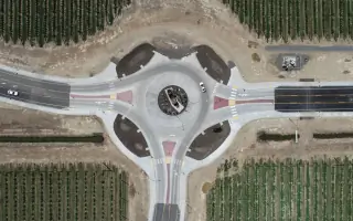
Transportation Engineering
Utility Engineering
Land Surveying
Construction Management
Funding Assistance
Planning
CAD Services
Drone Surveying
Details
- Year established: 1973
Highlights and features
- We offer 50+ years of experience in municipal engineering and land surveying
- Our team includes 15+ registered engineers and licensed surveyors
- We provide end-to-end project management from funding to completion
- Our patented drone surveying technology enhances project accuracy
- We maintain a 98% client satisfaction rate across 500+ completed projects
What people say
Quality project
Fantastic partner
Smooth and quick
Under budget
No concerns
Services
Transportation Engineering
Our transportation engineering services focus on designing safe, efficient roadway systems and infrastructure. We handle everything from initial traffic studies to final construction documentation. Our team ensures compliance with federal and state regulations while optimizing for community needs and environmental considerations.
Land Surveying
We provide precise land surveying solutions using advanced GPS and drone technology. Our services include boundary determination, topographic mapping, and construction staking. These critical services support accurate project planning and legal documentation for both public and private developments.
Construction Management
Our construction management team ensures projects meet specifications, budgets, and timelines. We provide quality control, contract administration, and on-site supervision throughout the construction process. This includes material testing, progress tracking, and coordination between contractors and stakeholders.
Funding Assistance
We help clients secure funding through federal and state grant programs. Our team prepares applications, cost estimates, and compliance documentation for programs like the USDA Rural Development and State Department of Commerce. This expertise helps communities access critical infrastructure funding.
CAD/Drone Services
Our CAD and drone services create detailed digital representations of project sites. Using drones for aerial surveys and advanced software for 3D modeling, we improve design accuracy and reduce field time. These technologies enhance project visualization and stakeholder communication throughout the development process.
Questions
What engineering services do you specialize in?
We specialize in transportation engineering, utility systems, land surveying, and construction management for municipal and private clients.
How can you help with project funding?
Our team assists with grant applications and funding strategies through federal and state programs like USDA Rural Development.
Do you work on private development projects?
Yes, we provide engineering solutions for private developers including site design, utility planning, and regulatory compliance.
What surveying technologies do you use?
We utilize GPS systems, drone technology, and advanced CAD software for accurate land mapping and project visualization.
How do you ensure project quality?
Our quality control includes regular site inspections, material testing, and adherence to engineering standards throughout construction.
Reviews (1)
R. Matus
Dec 21, 2018
Report
Civil engineer outfit with lots of experience in public projects. Beautiful facility with ample parking.